
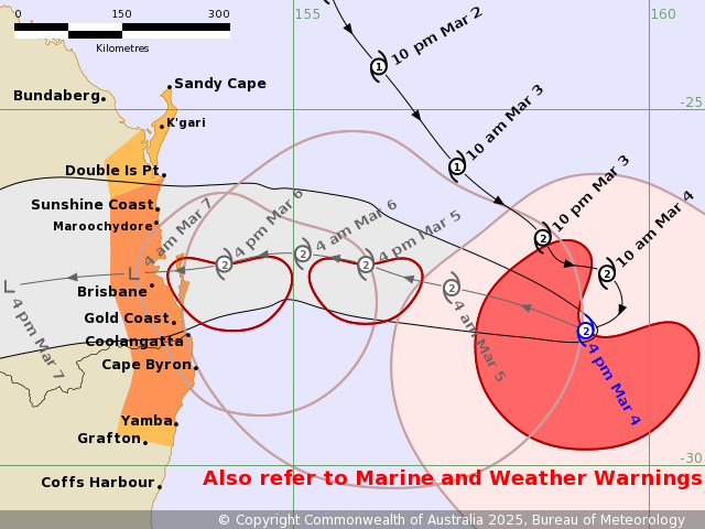
Tropical Cyclone Alfred has now taken a U-turn and trekking slowly West towards the South-East Queensland coast .
The once in a 50 year storm is currently 550 km east of Brisbane and 520 km east of the Gold Coast and is on track to hit the north of Brisbane late Thursday afternoon or early Friday morning.
The Bureau of Meteorology has updated its warning zone to Double Island Point in Queensland to Grafton in New South Wales. Brisbane, Gold Coast, Sunshine Coast, Byron Bay and Ballina are in the firing line.
The category two system is also sustaining its intensity with winds near the centre at 95 km per hour and wind gusts to 130 km an hour.
Gales with DAMAGING WIND GUSTS to 120 kilometres per hour are expected to
develop along the coastal and island communities during Thursday.
Heavy rainfall is also forecast for southeast Queensland and northeastern New South
Wales from Thursday.
HEAVY to locally INTENSE RAINFALL which may lead to DANGEROUS AND LIFE-THREATENING FLASH FLOODING may occur near and south of the cyclone centre as Alfred approaches the coast late on Thursday.
For more on the cyclone visit the Bureau of Meteorology Warnings page http://www.bom.gov.au/qld/warnings/


